 William BensonVIEW PROFILE →
Inside NASA's Mission to Chase Fire-Breathing Storm Clouds Over British Columbia
A retired Cold War spy plane, a record-breaking wildfire, and a race to understand the sky's most dangerous storms.
A retired Cold War spy plane, a record-breaking wildfire, and a race to understand the sky's most dangerous storms.
There's a moment, somewhere around 60,000 feet above British Columbia, where the curvature of the Earth becomes visible and the sky turns almost black even at midday. It's a place commercial airliners never reach — and for a few strange days in August, one pilot flew loops above it, alone, chasing a kind of storm that scientists still can't reliably predict.
The aircraft is called the ER-2. Most people have never heard of it. Aviation enthusiasts, though, know it by another name: the U-2, the legendary Cold War spy plane that once slipped past Soviet radar to photograph missile sites from the edge of space. Six decades later, that same airframe — retooled, repainted, and repurposed — is back in the sky. Only this time, the target isn't an enemy nation. It's a cloud.
What exactly is being studied
The cloud in question is a pyrocumulonimbus, or "pyroCb" among researchers — essentially a thunderstorm that a wildfire builds for itself. A large, intense fire sends up a column of superheated air carrying smoke, ash, and moisture. As that column punches upward through the atmosphere, it cools, condenses, and starts behaving like an ordinary storm cloud, except it's being fed from below by flames instead of ocean evaporation. Given enough heat and fuel, that early-stage cloud can mature into a full pyrocumulonimbus, a self-sustaining storm capable of producing its own lightning, its own violent winds, and in rare cases, its own fire tornadoes.
These aren't obscure or rare curiosities in a bad fire season — NASA describes them as one of the least understood forms of severe weather on Earth, and only a small fraction of wildfire smoke plumes ever cross the threshold into a true pyroCb. Researchers still don't fully understand what tips the balance, which is exactly why NASA sent a spy plane to go find out.
It sounds almost like the plot of a movie: a decommissioned Cold War reconnaissance aircraft, once used to photograph foreign military installations, now flown by NASA to eavesdrop on the sky itself. The logic behind it, though, is refreshingly simple. The ER-2 can fly higher than almost anything else in the air — well above the cruising altitude of any commercial jet — which makes it one of the only aircraft on Earth able to safely orbit directly above a violent, lightning-charged storm without ever flying into it.
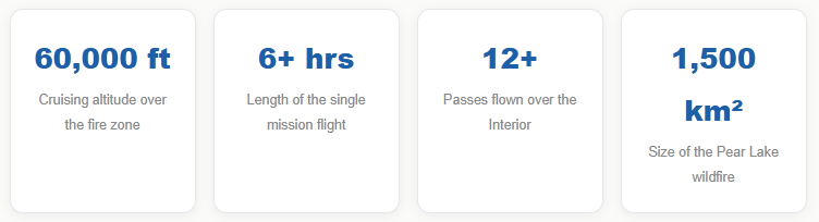
For the better part of a week in August, flight-tracking data showed the ER-2 crisscrossing the sky above British Columbia's southern Interior, flying back and forth more than a dozen times on a single mission lasting over six hours. It had taken off from Great Falls, Montana, and by the time it reached Canadian airspace it settled into a holding pattern at roughly 60,000 feet directly above the Clinton region, where the Pear Lake wildfire — the largest active blaze in the province — has been burning for weeks.
"Smoky and crackling with lightning, these unique storms can create blind spots for aviators above and spark new blazes below."
There was no passenger cabin, no crew of scientists onboard. Just one pilot, alone in a pressurized suit not unlike an astronaut's, flying what amounts to a very slow, very steerable satellite. Every instrument bolted to that aircraft pointed downward, tracking the fire's energy output, mapping the size and altitude of its smoke plume, and recording the electrical activity building inside the storm below.
British Columbia's brutal fire season, by the numbers
To understand why NASA picked this particular province for this particular mission, it helps to understand what British Columbia has been through this summer. The Pear Lake wildfire alone has scorched close to 1,500 square kilometers — an area larger than some small countries — and it's just one blaze among dozens burning across the southern Interior. Officials have confirmed the fire has already generated multiple pyrocumulonimbus events, storms strong enough to produce their own rain, their own lightning, and the kind of erratic wind shifts that can send a fire in a new direction within minutes.
What makes British Columbia such a hotspot, according to researchers on the mission, isn't a coincidence of geography alone. It's the combination of dense forest fuel, mountainous terrain that channels wind unpredictably, and increasingly hot, dry summers that leave the landscape primed to burn. Some of the largest fire-generated storm events ever documented anywhere on Earth have occurred in this exact corner of Canada — which is precisely why it became the focal point for a NASA field campaign years in the planning.
Meet INSPYRE: the science behind the flight
The mission has a name, and like most NASA projects, it comes with an acronym that's almost too fitting to be accidental: INSPYRE, short for the Injected Smoke and PYRocumulonimbus Experiment. Led by Peterson, the campaign is built around a single, urgent hypothesis — that as wildfires grow larger and more intense across a warming planet, they're pushing more and more smoke directly into the stratosphere, the layer of atmosphere that sits above where regular weather happens.
That matters more than it might sound. Smoke that reaches the stratosphere doesn't simply disappear. It can drift for months, circle the globe, and subtly change how much sunlight reaches the Earth's surface — a shift researchers call a change in the planet's radiative balance. In plain terms, wildfire smoke powerful enough to punch that high can behave a little like a small, slow-motion volcanic eruption, with climate effects scientists are only beginning to measure.
Why this mission needed two aircraft, not one
The ER-2 flew above the storm, mapping its shape, altitude, and intensity with radar and infrared sensors from a safe distance. A second aircraft, a Gulfstream V research jet, flew directly through the cloud at the same time, threading between lightning strikes to gather in-cloud measurements no satellite or ground sensor could ever capture. The two datasets are designed to inform each other.
What the instruments are actually measuring
It's worth pausing on how much the ER-2 can sense without ever touching the storm it's studying. Onboard radar estimates the physical size of the smoke plume and tracks how high it's climbing in real time. Infrared wildfire-tracking instruments — the kind originally developed for military reconnaissance — register the fire's heat signature from tens of thousands of feet away, essentially reading the intensity of the blaze itself. Separate sensors monitor the electric field building inside the cloud, effectively counting lightning before it strikes.
Put together, this creates something researchers have never really had before: a live, moving picture of a fire-generated storm from birth to peak intensity, recorded by an aircraft that never has to guess where the danger zone is, because it's always flying above it.
Why these storms are so dangerous
NASA's own researchers describe pyrocumulonimbus clouds as smoky, electrically charged, and capable of creating dangerous blind spots for nearby aircraft. On the ground, the consequences can be just as severe: erratic winds capable of pushing flames in new directions without warning, lightning strikes that spark entirely new fires miles from the original blaze, and in extreme cases, fire tornadoes powerful enough to uproot trees and damage structures.
A 70-year-old airframe, still working
There's something almost poetic about the choice of aircraft. The U-2 first took flight in the mid-1950s, built in secrecy to spy on the Soviet Union from altitudes so extreme that Soviet fighter jets couldn't reach it. It became one of the most famous — and controversial — aircraft of the Cold War. More than seventy years later, the same basic airframe, now flying under NASA's Airborne Science program as the ER-2, has been repurposed for the opposite mission: not espionage, but understanding. NASA operates two of these aircraft on a rotating list of environmental science missions, atmospheric sampling projects, and satellite calibration flights throughout the year. For a few days in August, its job was to face down what NASA researchers have started informally calling the "fire-breathing dragon of clouds."
Why forecasting these storms matters so much right now
Ask any wildfire pilot what they fear most, and pyrocumulonimbus clouds tend to top the list — not because they're rare, but because of how suddenly they appear and how violently they behave. Right now, forecasting these storms is closer to guesswork than science. There's no reliable early-warning system that tells firefighters, evacuation planners, or aviation authorities exactly when a wildfire is about to spawn a thunderstorm of its own.
· Map the smoke plume's size, altitude, and growth rate in real time using onboard radar · Track the fire's heat signature from above using infrared wildfire sensors · Monitor the storm's internal electric field to anticipate lightning activity · Cross-reference ER-2 readings with in-cloud data from the Gulfstream V jet · Feed the combined dataset into next-generation storm forecasting models · Build toward a genuine early-warning system for fire-generated thunderstorms
What happens with all this data
Data collection is only step one. Once the flights wrap up, the real work begins on the ground, where meteorologists and atmospheric scientists will spend months, possibly years, combing through the radar readings, infrared scans, and in-cloud measurements gathered during the campaign. The end goal is to feed all of it into forecasting models — the same kind used to predict hurricanes or severe thunderstorms — so that fire behavior analysts might one day be able to say, with real confidence, that a specific wildfire is likely to generate a pyrocumulonimbus storm within the next several hours.
That kind of advance warning would be genuinely transformative. It could change evacuation timing, reshape how firefighting resources get deployed near active blazes, and give pilots flying near wildfire zones a real tool for avoiding the most dangerous airspace, rather than discovering it the hard way.
A hotspot researchers didn't expect